
Buzzards Bay NEP Study of Salt Marsh Migration and Loss with Sea Level Rise
Last update: May 16, 2025.
Introduction
The Buzzards Bay National Estuary Program (BBNEP) is evaluating long-term migration and losses of Buzzards Bay salt marshes with sea level rise. Because tidal regimes differ slightly around Buzzards Bay, the real world elevation of the high marsh boundary (in the NAVD88 datum), also varies around the bay slightly. Consequently, in this study, the 1-foot, 2-foot, and 4-foot increases in sea level are added to the elevation of the specific upper boundary of the marsh in that part of Buzzards Bay.
The Buzzards Bay National Estuary Program will utilizes field elevation surveys and LiDAR data to conduct this analysis. To define the existing salt marsh boundary, we will use the regulatory definition of salt marshes under state regulations, namely the "high tide line," which is defined by the highest predicted tide of the year. This elevation is also referred to as the "annual high tide" and "King Tide" on our site. The Buzzards Bay NEP used the NOAA tidal models VDatum to calculate the precise NAVD 88 elevation of each tidal datum, and used used the data to estimate the high tide line. This elevation is applied to LiDAR digital elevation models to delineate a shift in the tidal datum spatially with 1-, 2-, and 4-feet increases in sea level. This data can be used by towns, state, and federal agencies to identify and prioritize restoration sites that will meet the challenges of climate adaptation. Towns can also use this information to target land acquisitions, or the removal of wetlands fill and anthropogenic obstructions that will impede inland migration of salt marshes.
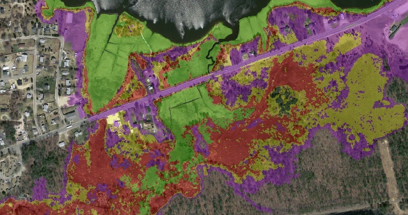 .
.Salt marsh expansion potential in an area of Wareham (along Rt. 6 near the Agawam River). The green shaded area shows elevations below the high tide line. Red = +1 foot sea level rise, yellow is +2 feet, and purple is +4 feet.
Importance of Salt Marshes
Coastal salt marshes are an important habitat and nursery for many marine species of plants, aquatic and terrestrial vertebrates, and invertebrates. Other functions provided by salt marsh ecosystems include storm damage prevention, prevention of pollution, protection of marine fisheries and wildlife habitat, and a source of primary production carbon that is the basis of coastal food webs. Salt marshes also contribute to aesthetic values of the coast. Historically, many salt marshes in Buzzards Bay have been filled or otherwise adversely affected by human activities.
Since the end of the last ice age, sea levels have risen hundreds of feet, and salt marshes have migrated inland in concert with the coastline. In recent centuries, it is believed that most salt marshes in protected areas have been able to accrete vertically to keep pace with rising sea level that stands at roughly 10 inches per century relative to the local rate. With global warming, the rate of sea level rise may increase. If vertical accretion within salt marshes cannot keep pace with rising sea levels, and if they cannot migrate inland, they will be lost.
Besides the potential threat of increased rates of sea level rise, two impairments are common in surviving salt marshes. First, many salt marshes have had tidal exchange with the ocean restricted by road construction and undersized culverts. Second, road construction and other fill have created hard boundaries to the inland migration of salt marshes caused by sea level rise.