Information about the High Tide Line ("King Tides") in Buzzards Bay
Under state and federal regulations, the highest tide of the year establishes the "high tide line." This highest annual high tide has been more recently nicknamed the "king tide." This predicted highest tide has regulatory significance in defining salt marsh boundaries under state regulations and defines navigable waters or waters of the United States under federal permits. This tide elevation may be less than any number of actual storm surge tides that may occur during a particular year.
For any area and year, you can check the tidal height predictions near you using the tide prediction graphic functions at: tidesandcurrents.noaa.gov. The actual time and elevation of a high or low tide on any given day can differ from the predicted times in tide tables because of wind, air pressure, and various sea conditions. Storm surge tides may exceed the regulatory high tide line.
King tides occur every 14 months. In practical terms, in Buzzards Bay there are several days in two consecutive months with nearly equivalent high tides (see the box below for all the highest tides in New Bedford during 2013). For example, in 2013, we made an appeal for photographs of King tides. In that year, the best daytime date to observe a king tide occurred in Buzzards Bay on Saturday, June 22 around 7:59 PM, about 20 minutes before sunset (and about 21 minutes after the full moon rose). On Sunday, the next day, the tide was about one-half inch higher, but that tide occurred at 8:49 PM, near the end of civil dusk, and so it was difficult to observe. An alternate date to observe the king tide that year was on Friday, June 21, 2013 around 7:08 PM, when the tide was nearly as high.
Of course, the actual time of high and low tides vary slightly around Buzzards Bay. On June 22, 2013 in Westport Harbor, it was 7:54 PM, at Onset Beach, Wareham it was 7:57 PM, and at Chappaquoit Beach, West Falmouth it was 7:50 PM. If you were visiting Cuttyhunk, Friday, June 21 at 8:11 PM was the best time to observe the king tide.
The Buzzards Bay NEP is always interested in king tide companion photographs showing exceptionally low tides that occurred during the same days about 12 hours earlier. Photograph pairs of the king tide with an average tide or a minus low tide for the same site are useful educational tools.
If you attempt to photograph a future king tide, go out about 15 minutes earlier to make sure you capture the event. The Buzzards Bay NEP is especially interested in receiving photographs of king tides within salt marshes in protected bays and estuaries. When taking such pictures, carefully focus on a rock, piling, or wave line in an area and take photos from several perspectives to show reference structures. Include photographs looking down at vegetation, as well as panoramic shots. Email your photos to Tracy Warncke.
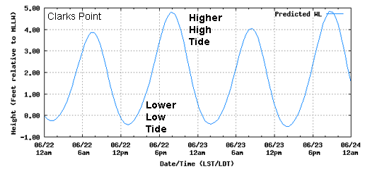
There are two reasons to take photographs of the predicted annual high tide. First, as part of a growing national "king tide" photo initiative, the annual high tide is a useful tool to communicate what future elevated sea levels will look like. For example, at Clarks Point in New Bedford, the elevation of the average high tide is 3.7 feet above Mean Lower Low Water, whereas the annual high tide or king tide at the same location in 2013 was 4.8 feet. Therefore, on June 22, 2013 you could have seen what a future "average" high tide might look like with 1 foot of sea level rise.
The second reason to document the annual high tide at a site is because of its regulatory significance as noted above. Where the annual high tide meets the land is called the "high tide line." Many activities below the high tide line require a federal wetlands permit. This is why, for example, when towns undertake beach nourishment projects, they deposit sand above the high tide line so that a wetlands filling permit is not required from the Army Corps of Engineers. There are similar ramifications for the high tide line under state and local wetland regulations and bylaws.
Is the high tide line the same as the highest beach wrack line? No. Typically, the highest wrack line on a beach coincides with the highest storm surge elevation that occurred in recent months. In any given year there will likely have been a storm surge that exceeded predicted annual high tide elevation.
The June 22, 2013 King Tide for Buzzards Bay
The Buzzards Bay NEP sought photographs of the June 22, 2013 king tide for Buzzards Bay. Some of these photographs appear on this website.
| Date | Day | Time of Day | Pred (Ft) | Pred (cm) |
| 5/24/2013 | Fri | 8:17 PM | 4.8 | 146 |
| 5/25/2013 | Sat | 9:05 PM | 4.8 | 146 |
| 5/26/2013 | Sun | 9:56 PM | 4.8 | 146 |
| 6/22/2013 | Sat | 7:59 PM | 4.8 | 146 |
| 6/23/2013 | Sun | 8:49 PM | 4.8 | 146 |
| 6/24/2013 | Mon | 9:39 PM | 4.8 | 146 |
| 7/22/2013 | Mon | 8:32 PM | 4.8 | 146 |
| 4/26/2013 | Fri | 9:23 PM | 4.7 | 143 |
| 6/21/2013 | Fri | 7:08 PM | 4.7 | 143 |
| 7/21/2013 | Sun | 7:42 PM | 4.7 | 143 |
| 7/23/2013 | Tue | 9:21 PM | 4.7 | 143 |
| 4/25/2013 | Thu | 8:37 PM | 4.6 | 140 |
| 4/27/2013 | Sat | 10:13 PM | 4.6 | 140 |
| 5/23/2013 | Thu | 7:29 PM | 4.6 | 140 |
| 5/27/2013 | Mon | 10:50 PM | 4.6 | 140 |
| 6/25/2013 | Tue | 10:31 PM | 4.6 | 140 |
| 7/20/2013 | Sat | 6:50 PM | 4.6 | 140 |
| 8/19/2013 | Mon | 7:25 PM | 4.6 | 140 |
| 8/20/2013 | Tue | 8:14 PM | 4.6 | 140 |
| 8/21/2013 | Wed | 9:00 PM | 4.6 | 140 |
| 9/19/2013 | Thu | 8:16 AM | 4.6 | 140 |
| 9/20/2013 | Fri | 9:00 AM | 4.6 | 140 |
The Tidal Cycle and King Tides Explained
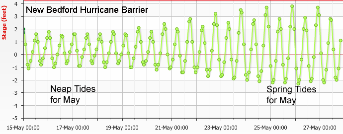
Tides cycle from high to low and from low to high roughly every six hours. More precisely, over every 24 hour 50 minute period, there are two high tides and two low tides. In Buzzards Bay, the tides are "mixed semi-diurnal tides", meaning in each day, one high tide is higher than the other, and one low tide is lower than the other. Each month, when the sun and moon are aligned (new moons and full moons) the high tides are much higher than usual, and the low tides are much lower than usual. These periods of monthly extreme tides are also called "spring tides." They occur every month, not just in the spring. On the other hand, each month when the sun and moon are perpendicular to one another (1/4 and 3/4 phase moons), the high tides are not very high, and the low tides not very low. These diminished tides that occur monthly are called "neap tides."

One day of tides (as predicted) in New Bedford at Clarks Point showing one high tide on a certain day might be more than a foot higher than the other high tide.

A month of tides in New Bedford at the Hurricane Barrier (as predicted) showing periods of spring and neap tides.
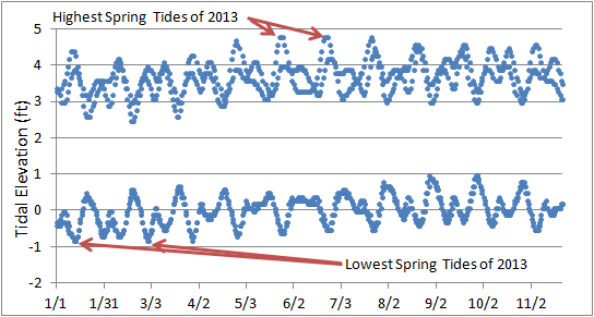
While the most avid fisherman and beach goers are familiar with these monthly patterns, there are additional tidal patterns that most people are not aware of. From month to month, the higher high spring tides and the lower low spring tides are not equal. In fact, there is a roughly 14-month cycle where the spring tide elevations (both high and low) rise and fall. This cycle corresponds to the "full moon cycle" where the moon is closer and farther from the earth (full moons appear to grow larger then smaller over the 14-month cycle; during the annual high tide, the moon will appear slightly larger than normal). In the figure below, we show the daily predicted high and low tides for all of 2013 as predicted for the waters off New Bedford. Keep in mind that these are just the predicted values, and on some days, tidal elevations were or will be higher or lower due to certain weather conditions, and during storms, tidal elevations may have been much higher.

A year of high and low tides in New Bedford at Clarks Point (as predicted) showing how the spring and neap tide elevations rise and fall in a cycle.
When characterizing average tidal elevations for a station, scientists use a 19-year tidal record period. This corresponds to yet a third lunar cycle, referred to as the metonic cycle, which is the period of time when the sun, earth, and moon, repeat nearly precisely their relative positions. Below is a summary of mean tidal elevations for key tide levels ("datums") for New Bedford at Clarks Point.
| 2013 Annual High Tide | HTL = | 4.85 |
| mean higher high water | MHHW = | 3.96 |
| mean high water (average of all high tides) | MHW = | 3.71 |
| mean tide level =(MHW+MLW)/2 | MTL = | 1.93 |
| (local) mean sea level (average of all tidal data) | MSL = | 1.67 |
| mean low water (average of all low tides) | MLW = | 0.14 |
| mean lower low water | MLLW = | 0.00 |
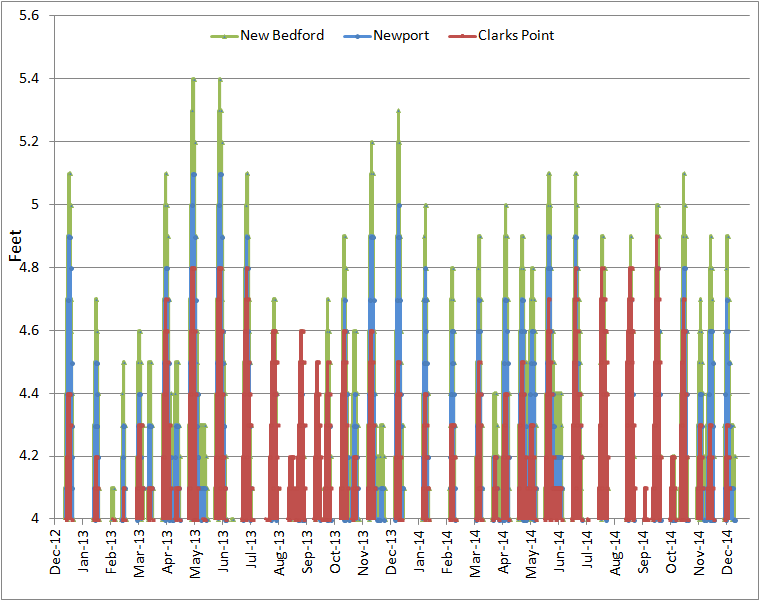
As noted above, the highest predicted tidal elevation during a year is called the "annual high tide", and where the water meets the land, it is called the "High Tide Line." These are specific terms used in certain state and federal regulations, and refer to the highest elevations in a particular year, instead of a 19-year cycle. Because annual high tides or king tides often occur on roughly a 14-month cycle, but numerous factors come to play with the positioning of the sun, earth, and moon. In 2014, the higher than average tides will occur in August, September, and October, and they will be more favorably split between daylight and nighttime hours. However, the tidal predictions in Buzzards Bay vary depending on the amount of data that has been collected for a station, and in 2014, the highest tides diminish over the course of 2014. Thus, some areas of Buzzards Bay will actually have their highest predicted tides on January 2, 2014. Still, throughout Buzzards Bay, the difference between the January 2014 and September 2014 spring tides will be mostly less than 3 or 4 inches.

Regulatory Issues
Under Massachusetts Wetland Protection Act regulations, the elevation of the mean high water (MHW) mark is based on the average predicted MHW during the currently adopted National Tidal Datum Epoch (1983-2001). Under federal law, the high tide line (HTL, or highest tide of the year), does not have a specific reference time period defined. This ambiguity has prompted some (like the state of Connecticut Department of Transportation, see the CT High Tide Line Committee recommendations) to call for a definition based on predicted highest annual tides during a tidal epoch. These recommendations were made into law and described at this CT DOT website.
