Climate Change Vulnerability Assessment and Adaptation Planning Study for Water Quality Infrastructure in New Bedford, Fairhaven and Acushnet
More information about the original solicitation for technical support can be found on our Vulnerability Study RFR page.
June 12, 2014 meeting information and agenda
The Buzzards Bay National Estuary Program, through the Executive Office of Energy and Environmental Affairs (EEA) and the Massachusetts Office of Coastal Zone Management (CZM), hired SeaPlan, an environmental planning firm, to conduct a climate ready estuary assessment and planning effort for the municipalities surrounding New Bedford Harbor. The purpose of this project is to develop an understanding of possible impacts of climate change and potential future responses by the Towns of Acushnet and Fairhaven, and the City of New Bedford. Of specific concern is how future increases of sea level, precipitation, and frequency or intensity of storms may affect public infrastructure related to water quality and habitat protection. The purpose of this Request for Responses is to select a vendor to adequately characterize the potential climate change impacts to certain public infrastructure, and identify and prioritize possible adaptation strategies. This work is part of a national effort by the US Environmental Protection Agency to encourage municipalities to enact long-term strategies to adapt to anticipated climate change impacts.
Goals of the effort
The overall goal of this effort is to improve public and governmental understanding of the vulnerabilities of New Bedford Harbor to future sea level rise and increased precipitation, frequency, and intensity of storms. This will be achieved through maps, meetings, workshops, GIS data, a report, and information posted on this website. The report produced shall outline strategies and actions needed to be implemented by the three participating municipalities. The information and recommendations in the report can guide municipalities to develop and implement climate adaptation strategies. These strategies will inform future changes in regulations, policies, site construction standards, and infrastructure maintenance planning. The specific outlined strategies in the final report can be used by the municipalities to develop grant applications to state and federal agencies. The ultimate goal is that information, strategies and actions will lead to a reduction in long-term vulnerabilities of the public and municipal infrastructure and private properties susceptible to the effects of climate change.
Background
The Buzzards Bay NEP and Massachusetts Office of Coastal Zone Management (MA CZM) have jointly conducted a draft evaluation of sea level rise impacts, using LiDAR data, to New Bedford Harbor. The harbor, which is shared by the City of New Bedford and the Towns of Acushnet and Fairhaven, is of interest because it is protected by a hurricane barrier that was constructed by the US Army Corps of Engineers in the early 1960s. The barrier and dikes protect a heavily urbanized and industrial area, an environmental justice community, a nationally important fishing fleet, and a center for the seafood processing industry. About 50% of the Buzzards Bay watershed population lives in these three communities.
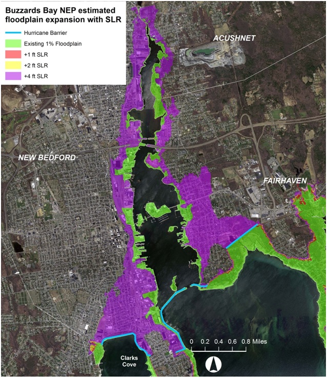
The Buzzards Bay NEP has found that the hurricane barrier will potentially have a widespread failure from the 1% storm ("100-year storm event") in conjunction with a 4-foot sea level rise scenario (see map below). Under lesser sea level rise scenarios, and coupled with expected higher annual rainfalls and more intense storms, the wastewater treatment facility, CSO system, and the municipal stormwater networks of each community may be appreciably impacted. These issues, and others related to climate change, need to be enumerated and characterized for the three communities involved. This task will be met primarily through hiring a contractor to assess existing data and information to characterize existing issues and needs relating to climate change impacts (sea level rise, increased precipitation, potential increased storm intensity and frequency) that need to be planned for in the three communities.
More information about our solicitation for technical support can be found on our Vulnerability Study RFR page.

