Tidal Elevations and Datums in Buzzards Bay
by Joe Costa
In any discussion of land elevations near the coast, it is important to understand and recognize that land elevations can be reported against different elevation datums. Vertical datums are the zero value to which you are measuring height. For tidal elevations, generally, mean lower low water (MLLW) is given as zero (the tidal datum). The elevation of MLLW relative to land elevation can vary within an estuary, and around Buzzards Bay.
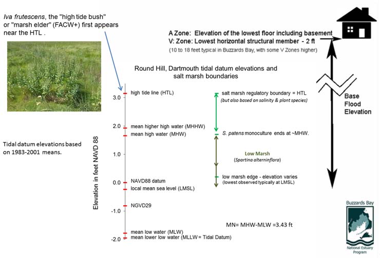
With respect to land elevations, prior to the 1980s, the zero land elevation (the datum) was measured against an average mean sea level calculated in 1929 over a large geographic area (called NGVD 29 in the 1970s, and originally called the Sea Level Datum of 1929). This "Mean Sea Level" elevation may or may not have coincided with any local mean sea level based on tidal records. After the 1980s, a new datum was adopted called NGVD 88. On the subpages provided here, are links and information about how LiDAR data sets can be transformed between these various datums. The figure below shows NGVD 88 elevations typical for Buzzards Bay of coastal features referenced on this website. Note, for example that in our area, salt marshes (high and low marsh) generally begin at or somewhat above local mean sea level, and continue to the high tide line (HTL, also now called the "King Tide"). Because of waves, currents, storms, and biological factors, the lower boundary of salt marshes is often somewhat above LMSL. Some scientific publications characterize the lower boundary of salt marshes as the tidal elevation "mean high water at neap tide" (MHWN). The low boundary of salt marshes are discussed in greater detail on our salt marsh boundary elevation page.

Notes on the regulatory use of tidal elevations
In the oceanographic literature, the definitions of various mean tidal elevations are well defined, and widely accepted (see this NOAA tidal definitions page and the NOAA Shorelines Glossary page). On the other hand, there are certain special regulatory definitions that also have special meaning. For example, the High Tide Line (HTL), the highest tide of the year (exclusive of storm surge), also commonly called the King Tide, is the upper regulatory boundary of salt marshes in Massachusetts and is the boundary for tidal waters under federal regulations. This elevation typically defines the upper boundary of the high marsh (Spartina patens), and the typical elevation of occurrence of the High Tide Bush, Iva fructens. The HTL, the highest tide of the past year, is usually lower than the Highest Astronomical Tide (HAT), which is the HTL for the current Tidal Epoch (a 19-year cycle defined by a repeating orbital dance of the sun, earth, and moon, currently calculated for the period 1983 through 2001).
When it comes to legal and regulatory definitions of tidal heights, there have been inconsistencies in regulations, and sometimes confusion about the definitions of tidal elevations. These uncertainties have sometimes resulted in legal challenges. As noted in Spillane v. Adams, 76 Mass. App. Ct. 378, in Massachusetts, the judge wrote, "no definitive standard for tidal marks has been adopted in our appellate case law." More on this case is included on the tidal datums and benchmarks page.
Army Corps Wetlands and Dredging Permits
For the purposes of federal permitting, "Navigable Waters" includes the area between mean High Water (MHW) and the high tide line (HTL). In 33 CFR Part 328 Definition of Waters of the United States, the High Tide Line is defined as "the line of intersection of the land with the water's surface at the maximum height reached by a rising tide. The high tide line may be determined, in the absence of actual data, by a line of oil or scum along shore objects, a more or less continuous deposit of fine shell or debris on the fore shore or berm, other physical markings or characteristics, vegetation lines, tidal gages, or other suitable means that delineate the general height reached by a rising tide. The line encompasses spring high tides and other high tides that occur with periodic frequency but does not include storm surges in which there is a departure from the normal or predicted reach of the tide due to the piling up of water against a coast by strong winds such as those accompanying a hurricane or other intense storm." The landward limit of "Tidal Waters of the United States" is defined by the high tide line for coastal areas.
The Massachusetts Wetland Protection Act Regulations (310 CMR 10)
Definition of a saltmarsh in 310 CMR 10.32 (2): "Salt Marsh means a coastal wetland that extends landward up to the highest high tide line, that is, the highest spring tide of the year, and is characterized by plants that are well adapted to or prefer living in, saline soils. Dominant plants within salt marshes typically include ...."
A Note about Nautical Charts
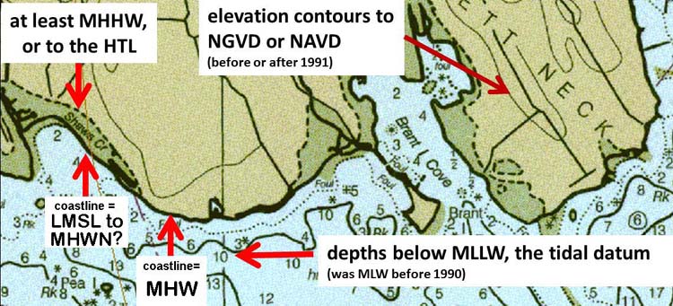
The shoreline on nautical charts is mean high water (MHW), except for areas of salt marsh, where the apparent shoreline is shown. The lower marsh boundary is defined by the amount of tidal inundation, and generally coincides with the mean high water neap (MHWN) line, which in Buzzards Bay is mostly about 1 to 1.3 ft above mean sea level (MSL). Around Buzzards Bay, MHW is mostly near 2.5 ft NGVD 29 or 1.6 ft NAVD88.
On nautical charts the bathymetry, however is relative to the tidal datum. Before 1990, the tidal datum on nautical charts (and used of other NOAA calculations) was set to MLW; after 1990, it was set to MLLW after 1990. This is only a 4-inch difference in most of Massachusetts.
This difference in datums between land elevation and bathymetry means a bathymetric depth of -1 foot is at a land elevation of -3 feet in NAVD 88 in Buzzards Bay, and greater north of Cape Cod. Land elevations on maps produced by the federal government before 1991 are NGVD29, and after 1991 are typically NAVD88.

