Comparison of Old Versus New Flood Insurance Rate Maps for the Buzzards Bay Watershed
FEMA Flood Insurance Rate Maps (FIRMs) are the basis of federal, state, and local hazard mitigation planning, used to establish the regulatory requirements for mandated flood insurance (mandatory for securing mortgage loans), and are used by building inspectors, conservation commissions, and other local regulators to establish standards for the siting, construction, and maintenance of buildings, sea walls, and land alteration. In the coastal zone, FIRMs generally define the 1% storm flood zone (commonly called the "100-year storm") as being either in the Zone V (Velocity or V-zone); which are areas subjected to waves greater than 3 feet during a storm, or Zone A, which are areas subjected to waves less than 3 feet during a storm. Most typically, these two zones are defined as Zone VE or Zone AE, which indicates that the zones have been assigned a base flood elevation (BFE) which were defined by a model or some other analytical procedure. The BFE corresponds to the top of the wave crest during the projected 1% probability storm. The methodology for determining these elevations and their boundaries are described in the Guidelines and Specifications for Flood Hazard Mapping Partners, Volume 1: Flood Studies and Mapping (FEMA, 2003).The predicted landward limit of the floodplain, as depicted in the FEMA FIRMs, corresponds to a specific real-world elevation as defined by the base flood elevation. The FIRMs prepared by FEMA are in fact an approximate depiction of which properties are in or out of the specified flood-zone elevation. While the FEMA FIRMs are generally good for broadly defining which homes are in or out of the jurisdictional flood zone, the maps are limited by the quality of topographic data that is available. Whether a particular structure near a mapped base flood elevation boundary is actually in the flood zone can only be determined definitively by actual field surveys. In fact, FIRMs can be amended based on such field investigations, and they often are.
The previous maps had been prepared mostly about 1985, but some were developed earlier. In 2009 and 2011, FEMA updated the FIRMs in Bristol and Plymouth counties based on recent LiDAR surveys (contracted by FEMA or USGS), and limited new coastal engineering analyses. Due to funding limitations, FEMA was unable to do new engineering analyses for all portions of each community. These new maps have increased precision and reliability, although like any data set, they are subject to errors in interpretation and processing of the elevation data.
FEMA has made the new floodplain maps available as GIS shapefiles. In fact, the new floodplain maps from FEMA are these GIS data files plotted onto georeferenced aerial ortho photographs. The old flood maps were issued as paper maps, and these paper maps were digitized and made available on the MassGIS website. This digitizing of the old maps was not always accurate across the entirety of map panels, but the work was accurate enough to allow for comparisons between the two data sets. By overlaying the two data sets, one can get a sense of where what new areas were added to the floodplain, what areas were removed, and what areas remained unchanged.
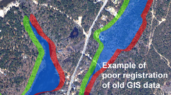
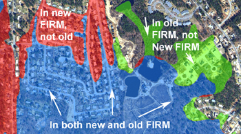
The map below left shows an example of a difference between the two GIS flood zone coverages that does not represent a real map change. Rather it represent a positional error in the digitizing of the old map coverage. These types of features are easy to identify because the flood zone area is the same shape, but it is just shifted slightly so that there is a new flood zone (shaded red) on one side of the feature, mirroring a similar loss of flood zone (shaded green) on the other side of the flood zone area. In contrast, the map below right shows an area that was genuinely added to the 1% flood zone (shaded red), and an area that genuinely removed from the 1% flood zone (shaded green).


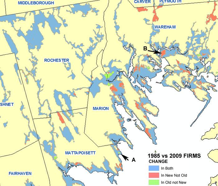
Below we show an overview map of the Bristol and Plymouth county coastal areas of Buzzards Bay, and we provide a Google Earth File for planners to examine the differences in very small areas. In light of the various limitations of these data sets described above, we urge caution on the use of the data files, and stress that it should not be used to definitively determine what structures are in or out of the flood zone. Still, many will find these maps instructive, and useful for a variety of evaluations.
Google Earth file for all of western Buzzards Bay:
fema_firm_old_new_change_bbw.kml
(49 MB kml file, right click file to save to a specific location on your computer. Open this file with Google Earth (TM), a free program.
Below is a map showing an overview of the FEMA FIRM map changes in the north end of Buzzards Bay. Please note that large red shaded "new" flood zone areas in northern Wareham and in a few other towns are ponds or swamps that were clipped out of the old GIS data, and they are not actual new flood zone areas.

Outcomes
Although FEMA has published and approved the new flood zone areas in 2009 and 2012, if map errors or data inconsistencies are brought to the agency's attention, they will issue a map correction known as a "letter of map amendment" (LOMA), and publish the correction on line. The Buzzards Bay NEP conducted this analysis as a preliminary step for our flood zone expansion with sea level rise project. In doing so we discovered what appeared to be errors of both omitted flood zones (example marked A on the map above), and erroneously included flood zone areas (example marked B on the map above). In June 2012, we notified the state about these errors, and they notified FEMA. As a result, FEMA and their consultant CDM Smith notified homeowners and municipalities about the errors, and initiated the process known as letters of map amendments (LOMAs). These LOMAs are expected to be finalized in December 2012. Read this FEMA LOMA notice for Mattapoisett and Wareham that was posted on the Town of Wareham website, as well as this similar announcement on the Town of Marion website.Other LOMAs are posted at the Starr Team website. Additional information about LOMAs and LOMRs are at the FEMA LOMA information page. Here is the actual LOMA published for the town of Mattapoisett, currecting the error near Aucoot cove: LOMA 12-01-2089p-102-i-a-c.pdf. This LOMA will be effective February 22, 2013.
